

News
June 2026
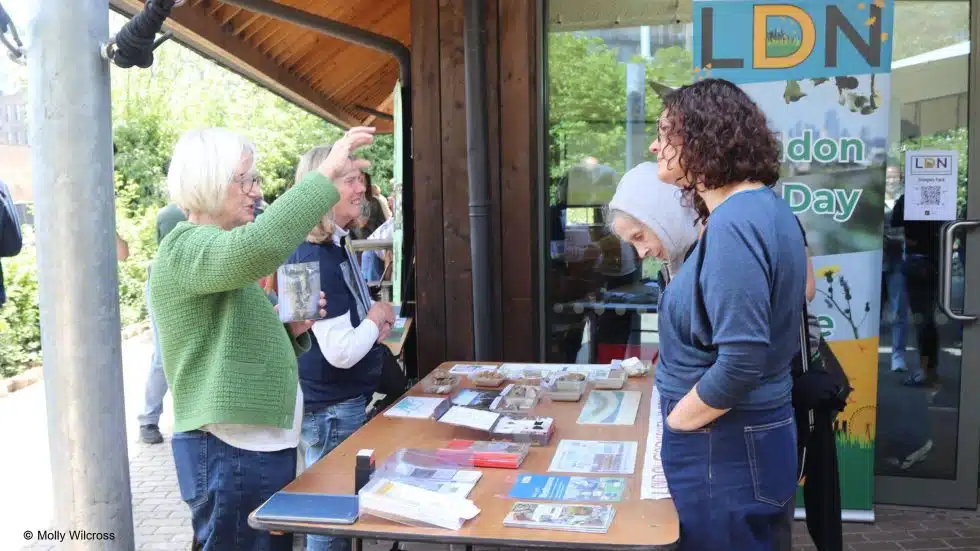
9th May at Camley Street Natural Park
London Geodiversity Partnership had a stand at the GiGL London Day of Nature this year. Read an article about the day’s events on the Greenspace Information for Greater London’s website.
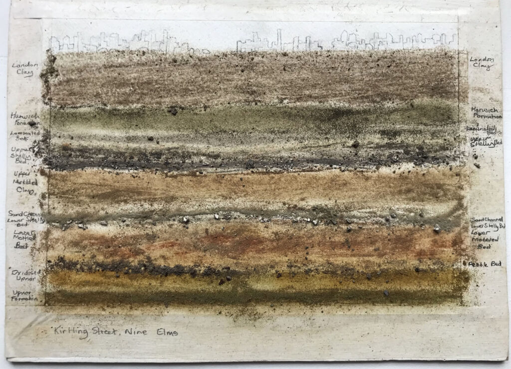
A new section of our website features artists who have collaborated with London Geodiversity Partnership and showcases their work.
January 2026
London’s Urban Geology in the News
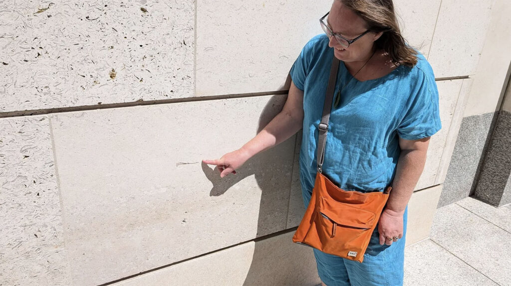
London Geodiversity Partnership member Ruth Siddall was interviewed by the journalist Ben Lerwill for an article published in The Guardian newspaper on January 21st 2026.
Read the article ‘Rock up to London: discovering stones and fossils from around the world on an urban geology tour‘ here.
Ruth also featured in Richard Fisher’s article for BBC Futures ‘Urban geology’: How to find fossils (and other discoveries) in your city’s buildings
December 2025
Layers of Bermondsey – the installation
The London Geodiversity Partnership attended on a wet morning when a new information panel was installed in Cherry Gardens next to Chambers Wharf. The lectern will tell passersby about the geology, archaeology and industrial past on this reach of the Thames. Artist and LGP member, Gail Dickerson, created the lectern with the support of the Community Enhancement Fund that will provide a legacy to the completion of the Thames Tideway Tunnel. Dee McLean was responsible for the design and layout of the panel.
October 2025
Geoconservation Day at Riddlesdown Chalk Pit
The London Geodiversity Partnership and the London Branch of the Open University Geological Society were joined by members of the Croydon Natural History and Scientific Society for our Geoconservation Day at the large Chalk quarry at Riddlesdown. The quarry is owned and managed by the City of London Corporation and, as usual, Matt Johnson prepared the base for a bonfire for the face we were to clear. He also kindly provided tea and coffee. Eighteen of us reported for duty which was a larger group than usual and in no time we had cleared the face where water seeping from the spoil mound has created a coating of tufa. We last cleared this area in 2017. This year, we not only revealed the tufa ‘wall’ but also a row of stalactites that we had not seen on our earlier visits. After our tea break, Liam Gallagher, a chalk expert and current GA President, took a group of geoconservers for a tour of the pit, explaining about the chalk in general, and putting the importance of the pit into context. This year the tour was also joined by members of the Amateur Geological Society who had come specifically to see the pit. Several stayed after, looking successfully for fossils. Very many thanks to all our volunteers – it is always rewarding to uncover something new!
April 2025
Gilbert’s Pit Geoconservation Day
The London Geodiversity Partnership with the OUGS London Branch have been maintaining the sections at Gilbert’s Pit since 2013 as they are used by engineering geologists tunnelling under London to see first-hand the very variable Lambeth Group. We again cleared brambles and scrub from both the east and south faces. Both had grown up since our previous meeting in 2023. TfL Underground engineers visited in March 2024 to view the Woolwich Shell Bed and the Reading mottled clay, and to consider what lies under London.
March 2025
Harefield Great Pit Geoconservation Day
The London Geodiversity Partnership obtained permission from Natural England to conserve the access to the face at Harefield in March 2024. The permission continues to 2028. We came back last summer to find the access from the footpath across the fields, normally worn by dog walkers, was totally overgrown. In March we wrote again to Natural England and received permission to conserve the two faces of interest, provided there was no recent evidence of badger activity. We spent the beginning examining the faces and discussing the geology. We were convinced that there was no evidence of badgers at Sites 1 and 2, although they were still active at Site 3 (not conserved). Many thanks to our band of 11 members of LGP and Harrow and Hillingdon Geological Society for the hard work.
October 2024
Riddlesdown Geoconservation 5 October 2024
Twelve people assembled for London Geodiversity Partnership’s annual geoconservation day at the large Riddlesdown Quarry in Croydon. It was a glorious October day and as soon as we entered the quarry the goats at the top of the quarry was an uplifting sight. Eventually they came down to see what we were doing but kept away from the bonfire and did not disturb us.
Read more and see some pictures here.
September 2024
Overground, Underground, Action Plan Meeting 2024
A public meeting was held in Lesnes Lodge on 6 September to discuss the way forward for the London Geodiversity Partnership over the next 5 years. The updated Action Plan will be published in due course.
August 2024
Sadly Peter Collins, a long-term and very active member of LGP died on 8 August, click here for an obituary
March 2024
Geoconservation at Harefield Great Pit 19 March 2024
Members of the London Geodiversity Partnership were able to clear the access to the SSSI at Harefield Great Pit on 19 March 2024. This is an important site for the contact between the Chalk and the overlying Upnor Formation revealing burrowing into the top of the Chalk from above and a horizon of very large flints. At a second face the top of the Upnor Formation and its junction with the Reading Formation has been obscured by falls. We cleared the access but not the scree on this occasion. A third section in the Reading Formation has been extensively burrowed by badgers and we did not clear access to that, nor did we attempt to access a fourth section up the hill through the woods where the top Reading Formation is overlain by the Thames Group (Harwich Formation and basal London Clay). We cleared two sackfuls of human rubbish as well as a couple of fox skulls. Anyone wishing to visit the site should contact Natural England for permission: protectedsites@naturalengland.org.uk.
March 2024
The Geological Society is safe in Burlington House
The LGP is very pleased to learn that three years after the first uncertainty to continuing in their home, the Geological Society and the other scientific learned societies have reached an agreement with the government to purchase a 999-year lease for their part of Burlington House. This provides security of tenure and when they have paid off the price of £5.5 million, they will occupy the premises rent free. Now they will be able to continue welcoming thousands of people every year to attend conferences, meetings, public events and exhibitions, to use the library and to view their collections. Further information can be found at: www.geolsoc.org.uk/burlingtonhouse.
June 2023
Geotrail from Sydenham to Dulwich (2023)
An eight kilometre walk from Sydenham Hill Station to West Dulwich Station to look at the Spas, Springs and Wells of South London. It goes through Sydenham Wells, Sydenham Hill Woods to Horniman Museum where there is a view through central London to the Hampstead ridge. After a lunch break the walk continues through Dulwich Park, past Dulwich Picture Gallery to Belair Park. This geotrail is dedicated to the memory of Paul Rainey who had the original idea.
April 2023
Geoconservation at Gilbert’s Pit Report
A report on the Geoconservation Day that took place on Sunday 16 April 2023 at Gilbert’s Pit jointly run by OUGS London Branch and London Geodiversity Partnership.
It is important to maintain the sections at Gilbert’s Pit as they are much used by engineering geologists tunnelling under London who wish to see first-hand how variable the Lambeth Group is. Every two years we aim to clear brambles and scrub from both the east face and the more spectacular south face. Both had grown up since our previous meeting in 2021. An extra session in spring 2022 cleared gorse and broom at the top of the quarry and the face at the top of the steps to allow South Bank University engineering students a good view of the Woolwich Shell Bed and the Reading mottled clay. The top platform has to be cleared of scree and steps cleaned at every session.


August 2022
Reinstating Branch Hill Pond – a progress report
The London Geodiversity Partnership has been working with the Redington Frognal Association to reinstate Branch Hill Pond on Hampstead Heath, made famous by Constable who included it in his paintings on many occasions between 1819-1836. In February we jointly mounted exhibitions at JW3 and in Burgh House, Hampstead outlining the project. Full details can be found here [link]
July 2021
Geoconservation Day at Gilbert’s Pit: Find about more about, and enjoy some pictures of, our recent geoconservation day…and it didn’t rain while we were working, only before we arrived!
March 2020
Burlington House Under Threat
Rents of the Learned Societies in Burlington House have risen 3000% since 2012 and are set to bankrupt them. Burlington House was originally conceived to bring together major cultural and scientific learned societies. Unless they can come to a reasonable agreement on affordable rents with the government, they will have to find alternative accommodation that will divert their precious resources. The Geological Society, the Linnean Society, the Astronomical Society and the Antiquarian Society are all under threat. An article in the Observer on Sunday 28 February highlighted the problem: www.theguardian.com/science/2021/feb/28/under-threat-the-birthplace-of-darwins-historic-theory, and the Geological Society of London launched a campaign with the other societies to reverse the rent rises. Conservative MP Tim Loughton is leading a cross-party group of MPs trying to secure a long-term deal for the societies with the Ministry of Housing, Communities and Local Government. The Geological Society outline ways in which members of the public can help with the campaign and anyone interested should follow that link: www.geolsoc.org.uk/burlingtonhouse.
November 2020


Details on the geology from the chief geologist on the project, Dr Tim Newman
The Thames Tideway Tunnel is a 25 km long stormwater storage tunnel, with an internal diameter of over 7 m; big enough to fit three London double decker buses side-by-side. Its route follows beneath the course of the River Thames, through central London, starting at 30 m below ground in Acton, west London, and reaching 65 m below ground at Thames Water’s Abbey Mills pumping staGon site in the east. Here it links up with the existing Lee Tunnel which continues towards Beckton at over 80 m below ground level.
Kensal Green Cemetery: in search of famous Geologists and Engineers
Presented for the Geologists’ Association Festival of Geology 2020 as a live trip during the Covid pandemic. In the event the trip had to be cancelled because of the second Lockdwown. Instead detailed walking instructions and information on those chosen have been written up. The tour is based round the monument to George Bellas Greenough in the 200th anniversary year of the publication of his geological map and many of the other tombstones selected are related to this event.
Devised by John Henry of the History of Geology Group and Diana Clements of the London Geodiversity Partnership with some details of the descriptions of the chosen heroes taken from publications by Eric Robinson and Henry Vivian-Neal.
September 2018
Overground Underground meeting 4 September 2018 at University College London
30 people attended the meeting and many ideas for the future were put forward which will be incorporated into the 2019-2023 Action Plan which will be posted on the website after the LGP meeting in February.

Britain’s prehistoric coastline discovered in west London
HS2 excavation uncovers black clay deposit that indicates the west London suburb of Ruislip was once a woodland marsh by the sea.
Interpretation of the findings by LGP partner Dr Jacqueline Skipper reported in the Guardian on 16/3/2018 (on line)
www.theguardian.com/science/2018/mar/16/britains-prehistoric-coastline-discovered-in-west-london

Image taken from the Guardian: www.theguardian.com/science/2018/mar/16/britains-prehistoric-coastline-discovered-in-west-london

Black clay deposit uncovered by the HS2 excavation
A transcript of the text can be read here.
September 2017
Riddlesdown Geoconservation Day

October 2016
Richmond Park Geotrail 12 October 2016
For the last few years the London Geodiversity Partnership has chosen Earth Science Week to run a public Geotrail. This year we joined forces with the Friends of Richmond Park to walk round looking for small exposures, views and springs to discuss the geology of this very interesting area. There are four different rock types that we discussed and the walk has been written up as a geotrail that will shortly be published on the London Geodiversity Partnership website. About 30 people attended and seemed enthusiastic about the geology underfoot. We hope to return for a repeat excursion in 2017.
Photos from John Lock (Friends of Richmond Park):

Max Lancaster of the Friends of Richmond Park talking to us about the history of King Henry’s Mound viewpoint. We also discussed the geology of the views to St Paul’s in the east through the ‘pinhole’ protected view, and to Windsor Castle in the west.

Di Clements talking about the Pen Ponds lying on a fault line through the park. As ever, new information on the digging of the ponds was gleaned from the audience.
8 October 2016 – Riddlesdown Geoconservation Day


The London Geodiversity Partnership made the large Chalk Quarry at Riddlesdown the focus of its conservation day for 2016. The quarry is owned and managed by the City of London Corporation and Matt Johnson prepared the base for a bonfire for the face we were to clear. He also kindly provided tea and coffee.As in previous years we worked in conjunction with the London Branch of the Open University Geological Society and invited members of other London geological groups to join us. Before starting work, Liam Gallagher, a chalk expert, talked to the group about the chalk in general and put the importance of the pit in context . This is what the face in Riddlesdown looked like before we cleared it. The event appropriately fell during Earth Science Week, improving access for research and study. Look at this lovely clear face at the end of the day’s hard work! Well done, volunteers – much better access!!
August 2016
A new App on London’s building stones, ‘London Pavement Geology’ is now available to download free from the iTunes App store, definitely for iPhone & iPad and for Android platforms too. It archives well over 1000 building stone localities within the M25. You can view these from the App and also submit new locations.
Both can be downloaded from our website via the links: http://londonpavementgeology.co.uk/mobileapp/
May 2016
New access at Gilbert’s Pit, Charlton unveiled on 18th May 2016
Gilbert’s Pit SSSI (Site of Special Scientific Interest) at Charlton in Southeast London is one of a number of former quarries worked in this area for their sand, gravel and chalk. This pit was primarily worked for the Thanet Sand used for moulding at the Woolwich Arsenal foundries and glass manufacture. Notified as an SSSI in 1953 it represents the only permanent exposure in the Woolwich area of the Woolwich Formation.
Steps have been built up the east side of the quarry face. They represent the result of extensive partnership working between the London Geodiversity Partnership, Natural England and the Royal Borough of Greenwich. The steps were jointly funded with a £10,000 grant from Natural England and £1,300 from Royal Borough of Greenwich who has overseen the project, providing a new gate, done tree felling and scrub clearance.
The LGP has organised volunteer workdays and given technical expertise, advising on which section to improve and helped scope the geotechnical survey undertaken by Capita Symonds.
Gilberts Pit steps
The steps were opened on Wednesday 18 May 2016 attended by representatives of Natural England, the London Geodiversity Partnership and Royal Borough of Greenwich Parks, Estates and Open Spaces Officers. The steps were “unveiled” in a ribbon-cutting event by Cllr John Fahy.
The photographs show the robust steps that will be able to be used by schools, geologists and be essential training for construction engineers. It provides a rare opportunity to encounter and understand the complex sediments that underlie much of London that can present significant challenges in strategic developments such as Crossrail. The platforms offer views of the disused workings where information boards are to be placed telling of the geology that can be seen.
Click here to download a pdf with more details and photos.
February 2015
Geology on the Underground
Open University Geological Society members are actively on the lookout for ‘Stone on the Underground’.
If you know of any stations where decorative stone has been used, do please contribute by contacting underground@lougs.org.uk.
For a list of what has been spotted so far see List of Stations checked: www.lougs.org.uk/localgeo/underground.htm.
January 2015
Geodiversity Charter for England launched. Click here for more details.
October 2014
The Guide to London’s Geological Sites is now available here. Over 50 important geological sites are described and can be explored further here. A complete pdf of sites can also be downloaded.
May 2014
GEOLOGICAL DISPLAY IN HIGHGATE WOOD
Geology and its uses in Highgate Wood and Queen’s Wood
A small display is on public view in the information hut beside the restaurant in Highgate Wood. Four story boards tell the story of the rocks beneath the local area and how they have been utilised in the past. A Romano-British pottery was discovered in Highgate Wood and an experimental kiln produced pots using the underlying Claygate Beds at the top of the London Clay. Flint debitage has been found and Highgate Wood was once known as Gravel Pit Wood. Highgate Wood forms a plateau whereas the topography of Queen’s Wood is very incised. The display includes minerals and fossils found in the London Clay as well as one of the experimental pots made on site.
Click here to download more details.
April 2014
Geoconservation at Chalky Dell
The London Geodiversity Partnership and London Branch of the Open University Geological Society arranged a geoconservation day at Chalky Dell. They were joined by members of London-based geology groups and local Conservation Volunteers from Lesnes Abbey and Shooters Hill.
Click here for more details and photos of the event.
April 2014
The Geology of London GA Guide covers ten Itineraries from within the M25 to provide snapshots of the rocks underlying London. It aims to cover all the rocks types that crop out within the area.
Several SSSIs including Harefield, Charlton, Abbey Wood, and Quaternary sites in east London are described. Chalk is described from the magnificent quarry at Riddlesdown, Croydon as well as underground at Chislehurst and Pinner. Geomorphology walks and the Geological Illustrations of Crystal Palace Park are also described. It is a multi-authored guide drawing on the best authority for the locations chosen.
Click here for more details from the GA website.
September 2012
London might not be an obvious destination for fossil lovers but here, Issy Gilbert, a palaeontology PhD student from Imperial College London, reveals the ancient world that can be found at some of London’s most famous destinations. http://www.bbc.co.uk/news/science-environment-19574619
August 2012
The Ilford Mammoth Plaque
In the 1860s numerous Pleistocene mammalian remains were discovered in Uphall brick-pit in Ilford. Amongst the finds there was a complete skull of a mammoth which is still on display in the Natural History Museum, London.
A plaque on Ilford Methodist church, Ilford Lane, which commemorated these finds had been installed during the 1951 Festival of Britain, but was stolen in January 2012.
In July 2012, a replacement plaque was installed by the British Pakistani Christian Association during the run-up to the London Olympics. Guest speakers at the unveiling were: Professor Adrian Lister (Natural History Museum London); William George (GeoEssex); and Terry Quirk (Ilford Mammoth Project).
Contributors to the design and text for the monument included: Ian Dowling – Local Historian for Ilford Central Library; Peter Collins ( London GeoDiversity Partnership); and the Natural History Museum Pictures Department and Palaeontology Department.
May 2012
Glacial erratic found in East London
In June 2011, when members of the London Geodiversity Partnership and GeoEssex, were visiting Marks Warren Quarry near Romford, East London, they discovered a boulder that had been found within the sands and gravels of the quarry.
marks warren boulderSubsequent examination of the boulder by Graham Ward of GeoEssex confirmed that it was a glacial erratic composed of an igneous rock, dolerite, transported to the site by the Anglian ice sheet, some 450,000 year ago. The characteristics of the rock, which appears to be a quartz-hypersthene dolerite, indicate that it may well have been derived from the Great Whin Sill, a prominent scarp in Northumberland, much of which is composed of this rock type.
During the Anglian glaciation the ice sheet spread as far south as London bringing with it rocks from the north of England and, if the petrology of the rock is confirmed, this boulder would be one of the furthest travelled, having been transported some 300 miles from its origin. This boulder would then have been washed down into the Thames catchment, once the ice had retreated, and deposited in the sands and gravels of the Black Park terrace, found at the quarry.
Due to the kind efforts of the quarry operators, Brett Aggregates Ltd, the 0.9 tonne boulder has recently been transported a few miles to the Essex Wildlife Trust’s visitor centre at Bedfords Park, Havering, where it is on public display. Only a short journey this time, compared with its geological history!
More information on the Marks Warren quarry site can be found in London’s Foundation here.
April 2012
The London Geodiversity Partnership attended a conference on the Engineering Geology of the Olympics, and presented a poster that can be downloaded here.
Consequently we are now working with the Environment Agency to publicise the new geology found in the Olympic Park as a result of all the ground investigations.
March 2012
Newly revised and updated, the latest version of the London Foundations Report has been published.
Please click here for more information.
September 2011
UK Geodiversity Action Plan website goes live.
It is also great to see that within this the London Geodiversity Partnership is well represented as a contributor to the UKGAP:
www.ukgap.org.uk/getting-involved/organisations/london-geodiversity-partnership.aspx